As archaeologists and heritage professionals continue to embrace digital technologies, two tools consistently come up in conversation and are leading the way in documenting and interpreting landscapes and built environments: LiDAR (Light Detection and Ranging) and photogrammetry. Each technique offers unique advantages, and understanding their technical differences is essential for choosing the right tool for a given site, objective, or budget. In this blog, we’ll explore how LiDAR and photogrammetry differ in methodology, data output, cost, and applications – particularly in the archaeological and heritage context.
How They Work: Light vs. Image
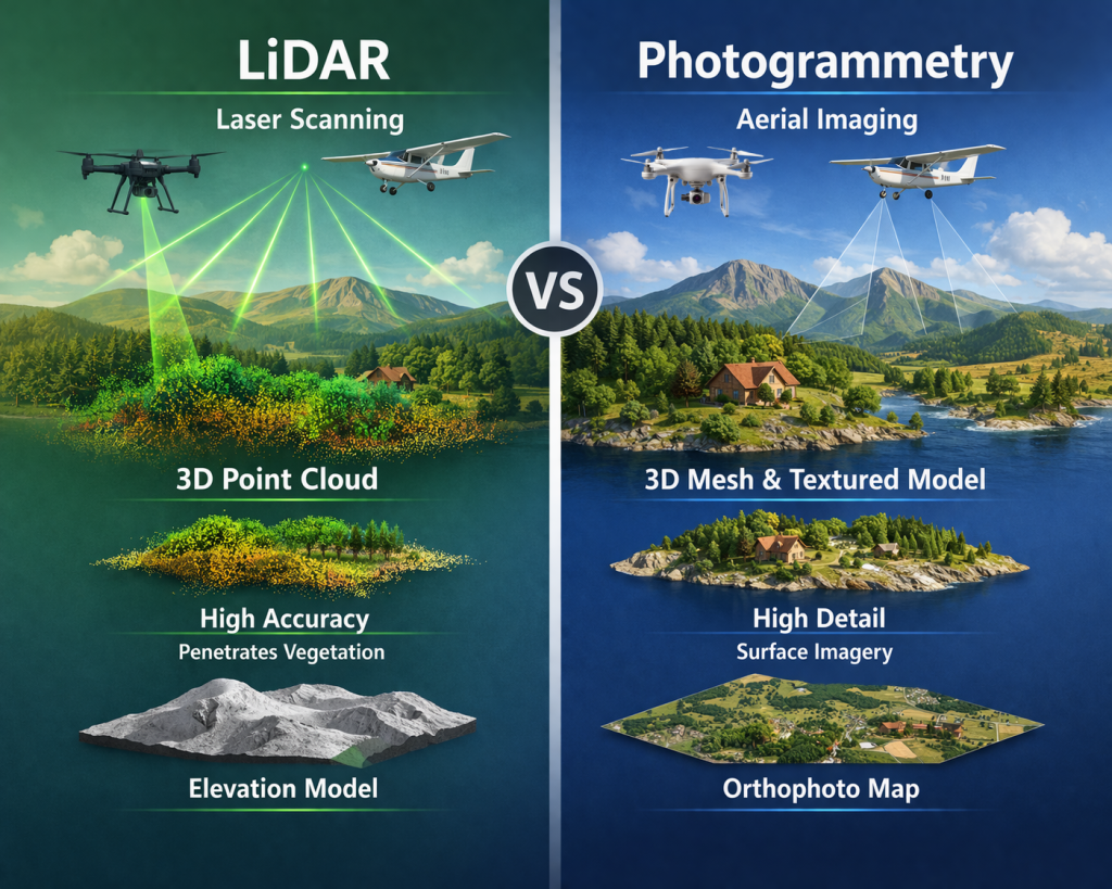
At their core, LiDAR and aerial photogrammetry differ a great deal in how they capture 3D data:
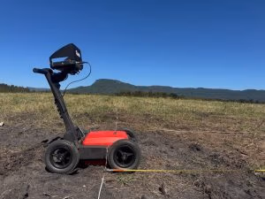
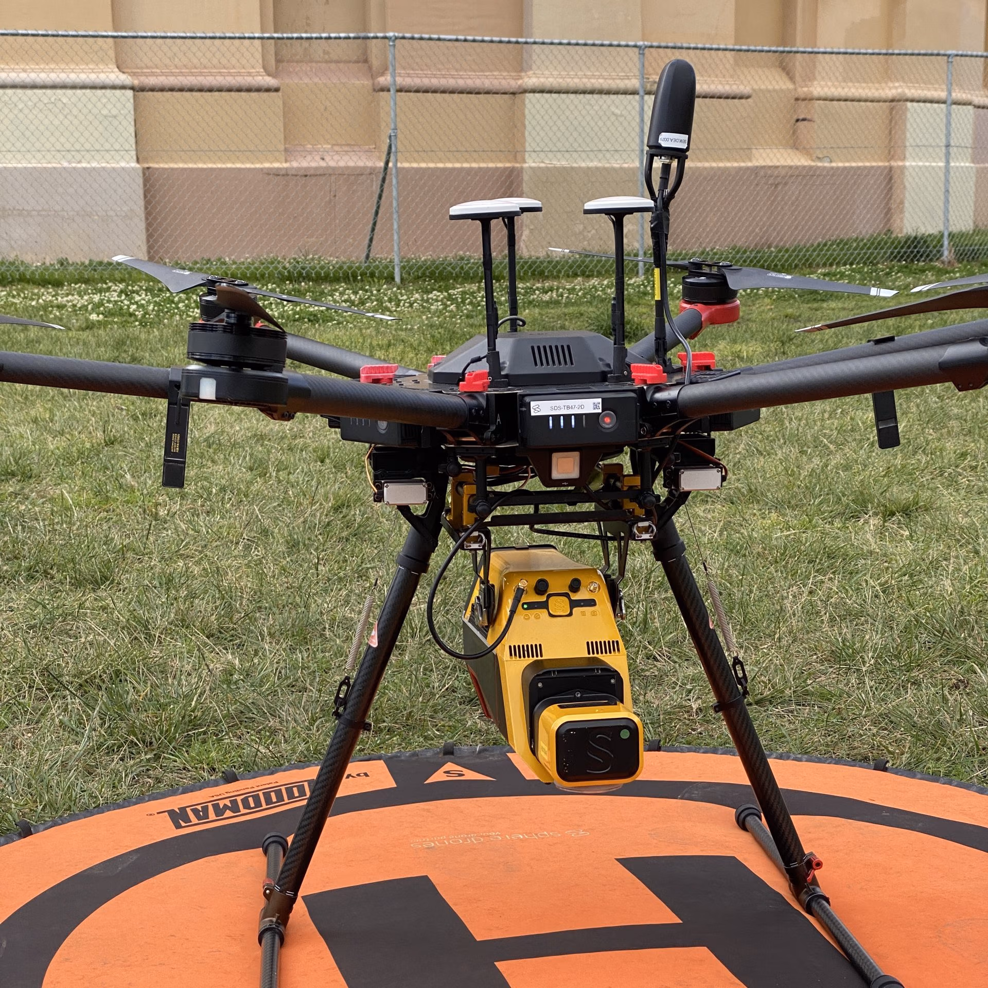
- LiDAR uses pulsed laser light emitted from a sensor (typically mounted on a drone, plane, or tripod) to measure distances to surfaces. Each pulse returns a precise measurement of distance, generating a dense “point cloud” of the landscape or object scanned. This method is active, meaning it emits its own energy and can function in low light or even darkness.
- Photogrammetry, by contrast, is a passive technique that reconstructs 3D shapes using overlapping photographs. Specialized software detects common features across images and triangulates their positions to build a 3D model or digital surface. Also known as structure from motion (SfM), it relies heavily on ambient lighting and good photographic coverage.
Accuracy and Resolution
Both methods can produce highly detailed datasets, but their strengths vary depending on the project:
- LiDAR excels at penetrating vegetation, making it ideal for identifying archaeological features hidden beneath forest canopies—like burial mounds, ditches, or ancient roads. Airborne LiDAR systems can achieve vertical accuracies of ±5–10 cm in good conditions, with point densities tailored to project goals.
- Photogrammetry typically provides higher visual resolution, making it well suited for recording fine architectural or artefactual detail. Models created from close-range or drone-based photography can resolve features at sub-centimetre scales. However, accuracy may be affected by lens distortion, lighting conditions, and errors in ground control if not corrected properly.
Data Types and Processing
The two methods produce different types of raw outputs:
- LiDAR produces a georeferenced point cloud, typically in LAS or LAZ format. These point clouds can include multiple returns per pulse (first return, last return, etc.), allowing users to differentiate between tree canopy, understory, and bare earth. From these, digital terrain models (DTMs) and digital surface models (DSMs) can be derived, and classified to isolate archaeological features.
- Photogrammetry creates a 3D mesh or point cloud by stitching photos into an orthomosaic and triangulating spatial coordinates. The result is often richer in texture and colour, producing photorealistic 3D models ideal for public engagement and conservation documentation. Software like Agisoft Metashape or RealityCapture is used to align photos, generate sparse and dense clouds, and create orthophotos or textured models.
Practical Applications in Heritage Work
Both techniques are used extensively across heritage projects, but with differing focuses:
- LiDAR in Archaeology
LiDAR is invaluable for landscape archaeology and large-scale survey. In Australia, it has been used to reveal songline-aligned travel routes, midden complexes, and ceremonial structures obscured by dense vegetation or sediment. Its ability to remove tree cover digitally makes it ideal for examining terrain morphology and hydrological features that shaped human occupation. - Photogrammetry in Heritage Recording
Photogrammetry is commonly used for detailed site documentation, particularly in built heritage and artefact recording. It is widely applied in 3D modelling of historic buildings, monuments, rock art panels, and excavation units. The outputs are often used in heritage interpretation, conservation planning, and virtual repatriation.
Cost and Accessibility
Cost and ease of use are key considerations for many heritage professionals:
- LiDAR systems are generally more expensive to acquire and operate. Airborne LiDAR surveys require specialized sensors and flight planning, often involving partnerships with commercial providers. However, prices are falling, and drone-mounted LiDAR units are becoming more accessible for small teams and academic institutions.
- Photogrammetry is more affordable and accessible. A basic setup requires a good digital camera (or drone), a calibrated scale bar or ground control points, and processing software. This makes it ideal for community-led heritage projects, field schools, or researchers working with limited budgets.
Integration: Not a Competition, But a Collaboration
Importantly, LiDAR and photogrammetry are not mutually exclusive. In many heritage workflows, they are used together:
- LiDAR provides the topographic framework—the contours of a site or region.
- Photogrammetry adds the surface detail, giving texture and material context.
For example, a LiDAR survey may map an ancient settlement’s layout beneath the trees, while photogrammetry captures the details of stone structures or decorated surfaces visible on the ground.
Final Thoughts
The choice between LiDAR and photogrammetry depends on the project’s scale, environment, and goals. Where vegetation obscures the landscape, LiDAR is unmatched. For close-up documentation and public communication, photogrammetry provides vivid results. Increasingly, heritage professionals in Australia and beyond are integrating both techniques—using technology not to replace traditional archaeology, but to enhance its depth, accuracy, and reach.
By embracing these tools, archaeologists can better preserve the past—whether etched into stone, buried in soil, or hiding beneath the forest canopy.