Geospatial Solutions for Heritage & Archaeology.

We believe the past matters as much to our present as it does to our future.

Advanced landscape modelling, geophysical survey, GIS, and analysis for heritage & archaeology. We're your technology partner!

Geographic Information System Modelling

Combining and layering data sets that include aerial based imaging, LiDAR, photogrammetry, terrestrial laser scanning (TLS), ground-penetrating radar (GPR), magnetometry, with advanced GIS modelling, we are adding to the story of places.

Geophysical Survey

Ground-penetrating radar (GPR) and magnetometry expertise provides a unique view of the subsurface. These technologies combined with a trained eye shed light on landscape use, aid in identifying burials and graves, and are assisting communities in truth-telling and healing.

Aerial Survey

Mapping & landscape imaging using RPA are providing unique perspectives on archaeological sites. 3D modelling heritage listed structures help conserve sites for future generations. Our experts report and contribute findings back to our clients so they can make better, data driven decisions.

Services for Archaeology, Heritage, & Conservation. CASA certified.
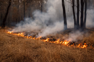
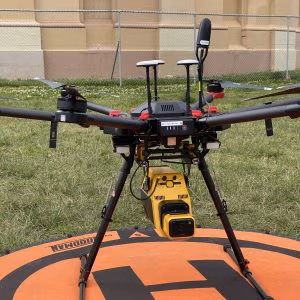
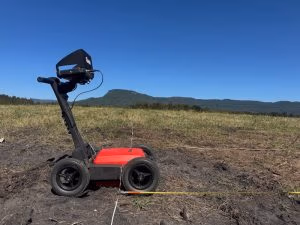
Advanced GIS, photogrammetry, landscape imaging with GPR, magnetometry, LiDAR and TLS. We provide an array of aerial/RPA services for archaeology and cultural resource management.

Unique Heritage Sites
+
Hectares Mapped
+
Photos taken
+
UAV Missions
+
CSIRO ON Prime

ON Prime Alumni 2023

The Up & Under team was proud to participate in the 2023 ON Prime program in Sydney. Dozens of conversations with Australian Archaeologists shaped the Up & Under business strategy. You spoke, we listened! 

We are digital archaeologists for archaeologists.

What we offer...

Temporal & Spatial Insights

GIS is so much more than just dots on a map

GIS allows archaeologists to analyse and visualise spatial relationships among archaeological sites, artefacts, and environmental features, aiding in pattern recognition and data integration. It helps in site selection, conservation planning, and predictive modelling, ultimately enhancing the efficiency and accuracy of archaeological research. GIS also facilitates cultural resource management (CRM), ensuring protection of heritage sites. Learn more... 

Payloads

There are a growing number of payloads available for drones such as LiDAR 

Unmanned Aerial Vehicles (UAVs) or drones offer spectacular insights into what’s above and below the surface of the land and waterscapes you’re investigating. The benefits of using drones across archaeology are vast, allowing archaeologists the ability to obtain a much wider range of results as well as create interactive data for presentation and research purposes and provide raw data for engagement by future archaeologists and interested community members. Learn more...

Centimetre precision of photogrammetric landscape captures

Photogrammetry in archaeology is a valuable technique known for its precise 3D reconstruction capabilities. It offers accurate representations of artefacts and archaeological sites, aiding in detailed analysis without physical contact, thus preserving the integrity of historical finds. Moreover, photogrammetry is cost-effective and efficient compared to traditional methods, making it an attractive choice for archaeologists. Learn more...

Geophysical Investigations Using GPR & Magnetometry

Geophysical approaches using GPR and magnetometry are unique techniques that can provide a strong context for past human activity, and evaluate their presence/absence within a heritage site. They provide the opportunity to map a site’s integrity with minimal disturbance. Learn more...

Community Resources for GPR

GPR has demonstrated the importance of geophysics as an approach to support Indigenous community focused projects that demonstrate Connection to Country, present broader discourse on Truth-Telling and Reconciliation, and establish agency. Outcomes can lead to broader social, cultural, political and economic impacts for local communities. This page has been designed as a resource with a lens on Australian and Torres Strait Islander communities. 

Consultants

Are you a consultant or heritage specialist? Click here to learn how a partnership with us can help your next project.

Academics

Are you an academic researcher? Click here to learn how we can help you with your next project

Our Recent Clients

Learn more...

Get in touch.

Contact us with your research or project requirements.

“We do archaeology differently because, we believe our past matters as much to our present as it does to our future”

Acknowledgment of Country

We acknowledge and pay respect to the past, present and future Traditional Custodians and Elders of this unceded nation and the continuation of cultural, spiritual and educational practices of Aboriginal and Torres Strait Islander peoples. This was, is, and always will be Aboriginal Land.